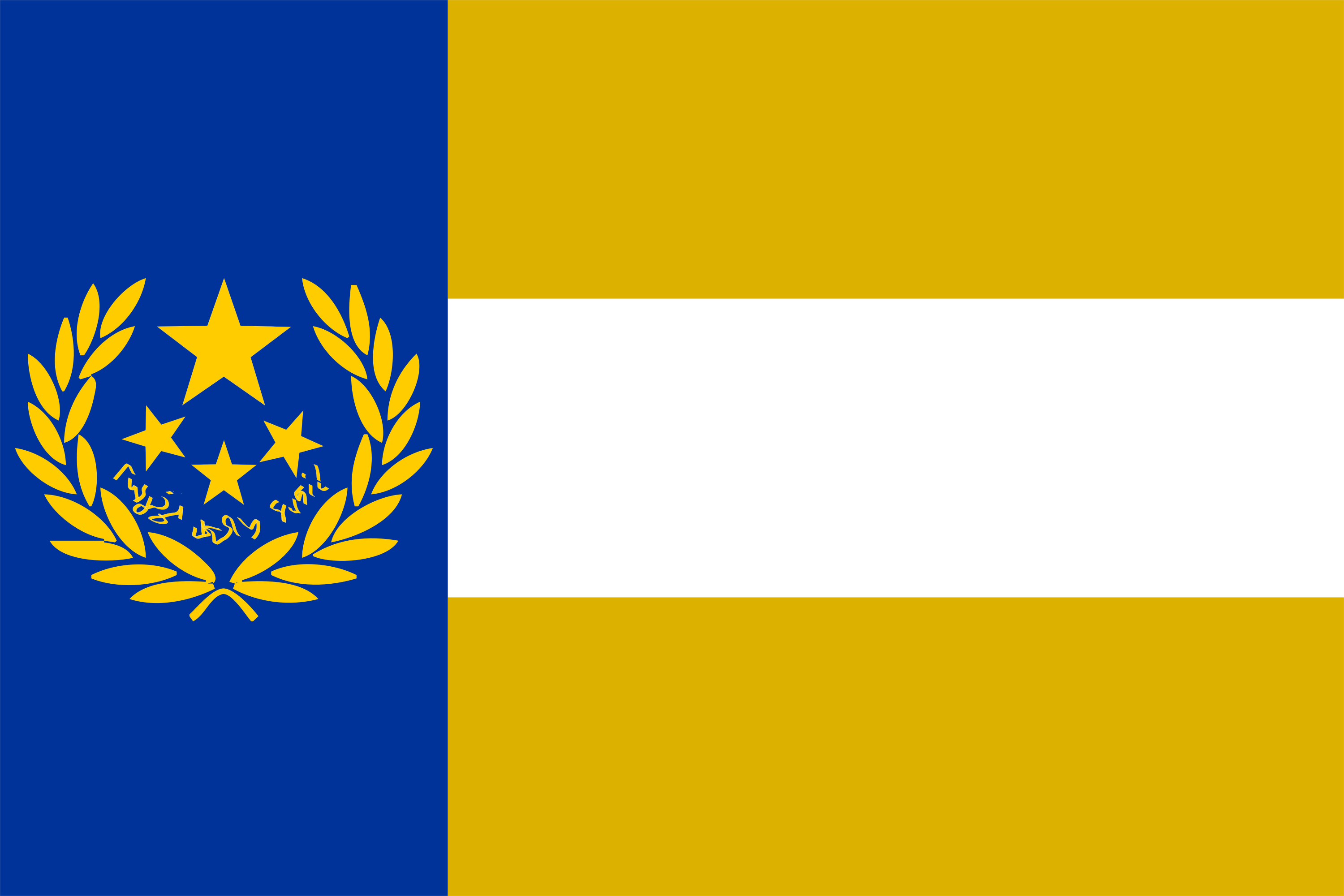

Selath, officially the Second Selathine Republic, is country in southern Zavoia. Selath is a global power whose core is located at a geographic crossroads between the Lonarian plain, the Edipar and Matravica mountain ranges, the Grondosphere, and the vast Thallian desert. Selath also controls colonies worldwide, including colonies in Gladria, the central and the eastern Thallian desert, Degafia, Halolagad, Tanmark, Zaprudea, the Pine Coast, Sparia, Aborasia, and Desuprina. Its capital and largest city is Pashed, which also serves as the cultural and economic heartland of Selath.
Though Selath is a relatively newer country compared to other superpowers of today, the Seliite people have lived in the Lonarian plain and the Edipar mountains since ancient times. Following the fall of the Artian Empire, Selath steadly grew to be one of the largest states in Zavoia and also its most powerful and influential nation. Under Thalorine the Great, Selath reconquered Morev and became what is now known as the Selathine Empire, Zavoia’s most powerful and influential state.As described by later Selathine historian Weslius Thebe,
“In the body of Zavoia, Vicus is the arm, Yesse the head, Moremia the heart, but Selath is the soul.”
Yet following the fall of Morev to the Fashis (1594), it slowly declined, until it was partitioned between the Fashi Reech, Baseloria, and Culagria in 1630.
Despite not existing as a state for much of the 17th and 18th centuries, Selathine culture remained strong, even if sometimes far from home. Selathines later settled in great numbers in Vicus, Baseloria, Koltara, and Ranjev, bringing with them their unique culture, their last-first name order, and their staunch Zascaic identity. In Selath proper, northern Selath under Baseloria prospered financially and industrially, while southern Selath under the Fashi Reech decayed and fell behind economically. Following the First Cyarik War (1710-1721), Fashi-controlled Selath fell into banditry, while the Baselorian north also suffered under harsh economic control from Zelo.
These conditions, plus a rise in Selathine nationalism and revolutionary ideals caused the breakout of the Selathine Revolution in 1752. Northern Selath gained independence from Baseloria as the United Counties of Selath a year later, and, after a period of brief but tumultuous monarchy between 1753 and 1758, came under the rule of revolutionary general, patriot, and staunch republican thinker Sedorague Hufarii. Under Sedorague’s rule, Selath underwent a massive modernization of its government, culture, and economy. From its independence, Selath under Sedorague immediately settled colonies in Sanctoria and the far southern Pine Coast. After the Second Cyarik War (1767-1770), northern and southern Selath were united once more, and the Republic tripled in territory, escalating it to a great power. However, Sedorague’s sudden assassination in 1774 threw Selath into a political mess, with the resulting Sello-Moremian War (1774-1775) ending in humiliation when the Moremians marched on Pashed.
Despite the humiliation, Selath still exerted its power worldwide, with industrial and cultural revolutions under a reformed presidential government from 1780 onwards. Great War (1808-1815) was particularly devestating to Selath, joining the war in 1808 against Moremia only to get partitioned yet again by Baseloria, Moremia, and Culagria. However, the Selathine resistance continued the war from the colonies, liberating Selath in 1814. The reestablished Second Selathine Republic was economically and politically ravaged, resulting in a military coup led by resistance leader General Guenam Bulin in 1824, who made himself President and eventually fuehlero (dictator) of Selath.
Today, Selath lives under the totalitarian rule of the Harmonist Party, a reactionary neo-adobean and nationalist movement that demands complete government control over society in the name of national unity. It rules as the sole legal party, enforced by the strongest military on the continent and a vast internal security apparatus. Yet Selath remains far from stable. Selathine workers, non-Zascaic minorities, regional dissidents, and remnants of the old resistance continue to challenge the regime. Abroad, the new Selathine state has intervened in the Baselorian Civil War and the Ronarian Revolution, alarming neighboring powers who fear the military, economic, and political capabilities of a restored Selath.
Name and Symbols
Etymology
The name Selath comes from the Artian Selathia, which was the name originally used to describe the northern half of the Artian province of Sellia. The name is derived from the Seliites, who settled the land in ancient times. These names possibly stemmed from the Old Cayatian term for ‘northener’: zeoloth. Another theory states that Selath, Sellia, and Seliite came from the Artianized Proto-Zarnic term Sulothe.
The endonym for the ancient Seliites established in 153 BMA might have been drouschsil; however the name Sellia and then Selathia gradually came into use by the populace during the reign of the Artian Confederation and the Artian Empire. By interfall times, the endonym for Selath became Selathya, meaning “Land of Selath”.
Flag
The current national flag of Selath was established in 1804, containing a triband in the following order: blue, yellow, blue, with a blue band on the hoist. The hoist contains the national symbol of the Republic of Selath: an Artian wreath surrounding one large star at the top, three smaller stars, and the national motto “In Sealtiel we rejoice” written in Selathine.
The blue and yellow colors were on the Selathine flag since its independence in 1753, taken from the Thalorgue standard of the old Selathine Empire. The blue represents the sky and sea, while the yellow represents either wheat or Zascaism. The Artian wreath is symbolic of the country’s history; the largest star represents the unity of the country; and the three smaller stars represent three major historical Selathine states: the Selathine Empire, the First Selathine Republic, and the current Second Selathine Republic.
Geography
Selath is politically separated into two entities: Metropolitan Selath to the north, and Colonial Selath everywhere else. Metropolitan Selath holds the capital, as well as 92% of Selath’s population. Separated by the Matravica mountains (specifically the Daeranga border established in 1779), colonial Selath has significantly larger land territory, but smaller population. Excluding its colonial territories, Metropolitan Selath is bordered to the east by Moremia, to its northeast by Noerrath and Culagria, and to its north by Baseloria. Including colonial territories, Selath also borders Vagrum, various Vicusian colonial territories, Tanith, Schonemark, Zenith, among other tribal lands. This geography entry will focus primarily on Metropolitan Selath, as geographies for each colony are covered in their respective entries.
Selath is situated in south-central Zavoia along the Artian landbridge that connects the Lonarian plain to the Manalian continent. Selath has a long coastline along the Arythine Sea, and a smaller coastline along the Lochian Sea thanks to the counties of Junipice and Siercia. Situated right on the world’s equator, the terrain is mostly defined by the rugged mountain ranges of the Edipars and Matravicas. The tallest mountain in Metropolitan Selath is Mount Dauson in the south (though of all Selathine land, the tallest is Mount Sedorague in Desuprina) Both mountain ranges are dotted with volcanoes. To the north is the vast Lonarian plain: a flat, dry steppe that covers everything from here to Koltara.
Due to being right along the equator of a colder planet, Selath is subject to a warmer sea climate. Though there were once large jungles in the time of the ancient Seliites, these remnants are small, cut and made way for farmland. Farmlands which are fertilized by volcanic soil from the Edipar mountains. This makes Selath and neighboring Moremia breadbaskets for the rest of Zavoia.
There are six major rivers in Selath:
- The Atmose River, which is the northernmost river flowing through Geriel and emptying around Thalorinaed into the Arythine Sea;
- The Tazre River, which is the lifeblood of much of central Selath, flowing through Pashed into a large freshwater lake known as the Sharie Sea, and emptying through Mirusa;
- The Azarie River, which is primarily in neighboring Moremia, but its source is in Selath. Morev is downstream from this river, and thus exists the moniker “Artia is the gift of the Azarie”;
- The Sorenne River, which starts in three places in the Edipars, flows through Genice, and empties in Corent.
- The Siercia River, which flows through Junipice in the East into the Lochian Sea;
- And the Balgothe River, which starts in the Matravicas and flows through the Deirdun plateau, emptying in Marsaed.
History
Prehistory and Moreyan civilizations
Humans began to settle in present-day Selath around 20,000 to 13,000 years ago, containing some of the world’s oldest proto-cities. The volcanic nature of the nearby Edipar mountains made the soil extremely fertile, resulting in the rise of Suenumburi, one of the oldest cities in the world, around 10,000 years ago along the Tazre. Today, Suenumburi is a district in southern Pashed. Other extremely ancient cities are the sites at Genambulie, Kielate-Hasana, and Maga-on-Atmose.
Around 2,000 years ago, a proto-Artianic group known as the Moreyans settled the Tazre river valley